Since I’m a committed Android user, Garmin Pilot is just about the only app out there that provides an intuitive and stable electronic flight bag for my general aviation needs. I’ve been flying more and more with the local Civil Air Patrol crew, and their G1000 equipped Cessna 182 has spoiled me. The moving map on the G1000 shows a lot more information than has been available on the Garmin Pilot app, but it looks like Garmin is slowly adding those features in — and more. Here’s what’s new in version 4.3, and how it works in practice.
The biggest feature improvement is terrain and obstacle awareness. This is a feature that I really appreciated in not only the G1000 but also the Garmin GNS-430 that is in the 172 that I rent from a local FBO on occasion. As a VFR pilot my eyes should always be outside, and I should be able to see a tower than I’m about to hit, but having some backup makes me feel a little more comfortable. Another set of eyes never hurts.
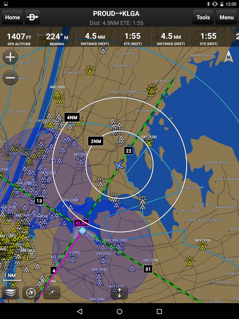
Just like with the G1000, the obstacle icons go from white to yellow to red when your altitude gets close to the top of the obstacle (and are all listed with the height in MSL and AGL). The terrain also changes colors to alert you when you get close, as indicated by the legend in the bottom left. There’s also two reference markings available, a forward facing fan (shown above) and a fixed distance circle around the airplane.
The terrain feature is implemented basically the same way that they did it in the G1000, but with some added bells and whistles. The obstacles can be displayed on all chart types (except approach plates and such), but they aren’t added by default. You need to select them from the “overlays” section on the chart options area. This will display all obstacles everywhere on the map.
The other way to turn on obstacles is through the General settings tab, where you can choose to show only those obstacles nearby your position and nothing else. This will keep the map pretty clutter free in areas like New York City where there are obstacles all over the place.
Once enabled, the obstacles work just like they do in the G1000. The obstacles are white when they are no factor, yellow when you’re getting close, and red when they are near your altitude.
The obstacle database is only available on Android for the United States, but that’s not all you get. The terrain database is also included, and shows up like a background image on the Garmin VFR and IFR maps. The nice thing is that this isn’t US only — they provide terrain for the entire world with one subscription.
If you want to see the terrain as well at the same time as the navigation data, you can by swapping out the “panel” instruments for the terrain display. But you can’t have both, at least not that I’ve figured out yet.
While obstacles and terrain are a great addition to the feature set, something that will make it easier for pilots to get comfortable with the app and using it in flight is the brand new X-Plane integration.
For those who have X-Plane 10 installed on their computer, Garmin Pilot will readily find and use the data output from the simulator and make the app sync up with what’s going on. That includes all of the data, too — not just the GPS position but also the attitude information, which makes the attitude indicator come alive on the app’s panel.
I actually used that X-Plane integration to test out the new features and take the screenshots included in this post. I grabbed a 747-400 from KDFW and started flying it around, and the app kept pace perfectly. Setting it up was easy as pie — click a few buttons, and things come alive.
These are some really cool improvements. I just hope that they continue to tweak things, and hopefully add obstacles into the moving map display.


Today, 7-7-15, I called Garmin to ask if Garmin Pilot would integrate with ADS-B receivers other than the GDL-39, specifically the Dual XGPS170. They said it would. Have you tried it recently?
I’m sure it works with the external GPS functionality, but as for the ADS-B functions I haven’t been able to verify that. I’ll get back to you on that.
I seem to be having issues with connecting X-Plane To GP using my iPhone 6s Plus. When I called Garmin, the guy was not aware of a way to connect GP to X-Plane nor was he aware that other EFBs like FF, FlyQ and WingX did as well. There has to be a way, but all I can find is old posts for android devices connecting GP to X-Plane. Has anyone successfully connected GP with an iOS device? I really want to be able to use GP and not have to purchase FF again.
Garmin Pilot has a specific function for connecting to simulators. It’s on the GPS tab in “Settings” in the Android version.